
Looking Up Pomona Neighbors
A block lookup needs different evidence from a whole-street search. The subject parcel is the anchor, adjacent AINs define the map, and each selected lot needs its own record check. The voter system is not a public block browser. Directories and census schedules can show listed adults in a historic year, while community pages can show a public organizer or event contact. No source supplies every household.
| Source | What It Shows About a Block | Access |
|---|---|---|
| Assessor GIS | Parcel pattern, AINs, adjacency, use, building data | Free map viewer |
| Parcel detail | AIN, situs, roll values, parcel and building clues | Free address or AIN search |
| Recorder deeds | Recorded ownership chain for a selected parcel | Index and copy request; no broad web index |
| Historic directories | Listed adults and businesses in street-number order | Library, microfilm, or digital edition |
| Census schedules | Released households in enumeration geography | NARA, FamilySearch, or library database |
| Neighborhood groups | Public officers, organizers, contacts, and events | Group or city page; rosters usually private |
Use the parcel source for geography, the recorder for a selected ownership question, and the local history sources for an earlier block. Neighbors are a place relationship, not a single database field.
Click Every Parcel Around Pomona
The basic Assessor map has no verified public radius or buffer export. The block method is manual. Search the subject address or AIN, center the map, select the parcel, and then click each touching or facing parcel. Open each parcel detail separately. Zoom and pan along the street for orientation, but keep the AIN with every note.
- Search the subject address in the Los Angeles County Assessor map.
- Save the subject AIN, situs, parcel outline, and use or building clues.
- Click each adjacent or across-the-street parcel and record its AIN separately.
- Open parcel detail for each selected AIN rather than assuming one street number covers a whole lot.
- Use a deed or city file only after the parcel and jurisdiction are clear.
The captured parcel detail gives a concrete starting point for the surrounding-lot method.
Open the Assessor parcel-detail example before browsing the surrounding Pomona block.
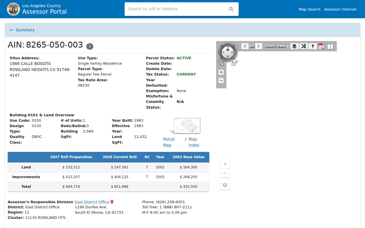
One selected parcel is a starting point. Every neighboring AIN needs its own source check.
Pomona Neighbor Parcels Across Streets
Two parcels can face each other without sharing land, ownership, or a household. A corner lot can touch two streets. A multi-unit property can have one assessor situs and several postal units. A public map line can also look exact while remaining an assessment aid rather than a survey. These details matter when a Pomona neighbors search tries to describe a block from a screenshot.
Use the map for pattern and orientation. Use the deed's legal description for land identity. Use the city or county planning custodian for a boundary or permit question. The county's parcel map, imagery, and parcel detail can update on different cycles, so a recent change may not be visible in every layer.
Note: Physical adjacency is a map relationship; it is not evidence that two people know each other, share an owner, or live together.
Pomona Neighbor AINs Keep Blocks Straight
AINs prevent a common neighbor-search error: attaching a deed, tax clue, or building file to the wrong parcel with a similar address. Save the subject AIN and each adjacent AIN before looking for names. The assessor public web display suppresses owner-name searching, so an AIN is the practical bridge to a lawful office inquiry or a recorder request.
A deed request is not address keyed. It needs party names, title or document type, year or range, and other identifying facts. Once one parcel's acquisition deed is found, the grantor and grantee chain can be followed backward. The chain remains a selected-parcel history, not a list of all Pomona neighbors.
- AIN
- Assessor Identification Number, the county key for a parcel.
- Adjacent
- Touching or near a selected parcel on the map, subject to map limits.
- Situs
- Physical parcel or structure location.
- Deed
- A recorded instrument that can identify parties and land transfer.
- Buffer
- A surrounding area drawn around a feature; the basic Assessor map has no verified public export for it.
Pomona Neighbor Limits for Parcel Owners
A deed can identify a recorded owner or party. It does not identify every adult, family member, visitor, or person who uses the structure. A homeowners' exemption can support an owner-occupancy clue, not a household roster. A permit may name an architect, contractor, applicant, or agent. A tax bill may connect to a mailing address that is not the situs.
The LA County voter-status form is narrower still. It requires a last name, birthdate, house number, and ZIP code for a person's own check. California Elections Code §2194 limits qualified voter-file uses and protects selected identifiers. There is no ordinary public voter block browser for Pomona. A nonmatch can mean formatting, movement, inactive status, cancellation, or no registration.
Historic Pomona Blocks in Street Order
Earlier Pomona neighbors are often found in the criss-cross or reverse section of a city directory. Start with the street name, move by house number, and copy each listed adult or business with the edition date. The library describes city and phone directories from the late 1890s through the present, with 1896 to 1945 microfilmed. Known editions include 1896, 1898, 1903, 1907, 1909, 1911, 1914, 1916, 1919, 1922, 1926, 1931, 1940, 1945, 1948, and 1951.
Pair the street section with census schedules, newspapers, deeds, and obituaries. A directory can omit a household, use an abbreviation, or reflect publication lag. A historic block view is strongest when the same address and nearby names recur across editions, not when one isolated line is treated as a complete roster.
The Pomona city directory collection reference explains how to read the volumes and test a household across years.
Pomona Has No Voter Block Browser
LA County's voter status tool is a self-verification form, not a public list of Pomona neighbors. The full voter file has purpose, requester, field, geography, certification, and payment rules. California's Elections Code limits permissible uses. Protected addresses, signatures, driver-license data, and Social Security information are not open fields, and a voter history record never reveals ballot choices.
For a lawful records question, use the published RR/CC voter-record route and describe the permitted purpose. A block extraction cannot be justified as a casual neighborhood search. If the question is about one person, the person must be able to enter the required private information or the request must meet the county's qualified-file rules.
Note: The absence of a public block browser is a privacy boundary, not a missing feature to work around.
Pomona Groups Publish Contacts, Not Rosters
Pomona's neighborhood layer includes City Neighborhood Services, council districts, recognized neighborhood and community organizations, and place-based groups around Downtown, Lincoln Park, Phillips Ranch, Westmont, and Pomona Valley campuses. Public pages may name an officer, organizer, event, or contact route. The research did not locate a current official master inventory that establishes which groups publish member directories.
| Community Layer | Publicly Useful Clue | Boundary |
|---|---|---|
| Pomona Neighborhood Services | City contact and neighborhood-service layer | Not a household roster |
| Downtown and Lincoln Park | Place-based history and community contacts | Public roles vary by group |
| Phillips Ranch and Westmont | Area context and local organization leads | No verified complete member list |
| Pomona Valley campus groups | Public events, offices, and organizers | Member lists generally private |
Pomona Neighborhood Services is the appropriate public contact layer for city neighborhood information. HOA membership lists, congregation rosters, and watch-participant lists should remain private unless the organization publishes a consent-based directory.
City contact material can help identify a council district, public meeting, or organizer who chooses to be visible. It cannot establish that a person lives in a particular house. A CPRA request may seek an existing city record about a named program, address, or date range, subject to exemptions and redaction. It should not ask the clerk to assemble a block roster from unrelated systems.
Near Pomona's edge, confirm whether the parcel is incorporated before treating a neighborhood label as a city record. County GIS-NET is designed for unincorporated Los Angeles County, so it is not the primary zoning authority for Pomona proper. The Assessor map and Pomona planning records must be joined with that boundary check.
That distinction matters for Downtown, Lincoln Park, Phillips Ranch, Westmont, and the Fairplex side of Pomona. A public group contact can help with local context, while the parcel and city boundary decide which official record route applies to a Pomona neighbor question.
Privacy Limits on Pomona Neighbors
Official records and compiled neighbor tools do not carry the same weight. Official records are tied to a named custodian, a defined field, and an access rule. Compiled tools may merge namesakes, repeat old addresses, omit protected changes, or infer a relationship that the source never stated. A category comparison helps set the right expectation.
| Route | Strength | Limit |
|---|---|---|
| Assessor and GIS | Parcel identity, AIN, shape, use, building clues | Owner name withheld online; map is not a survey |
| Recorder deed | Recorded parties and land transfer | Not a household or street-address web index |
| Directory or census | Historic adults and households | Date-bound, incomplete, and edition-specific |
| Compiled neighbor tool | May offer a broad lead | Accuracy, source, currency, and lawful-use limits vary |
Lawful personal use. Pomona neighbor records can support local history, family research, property curiosity, and civic work. Do not use them to stalk, harass, intimidate, impersonate, or harm anyone, and do not attempt to defeat a confidentiality program.
When a block question reaches a protected person, private roster, sealed file, or unsupported inference, stop at the boundary. A neighbor lookup is more trustworthy when it names the parcel and source rather than inventing a household.